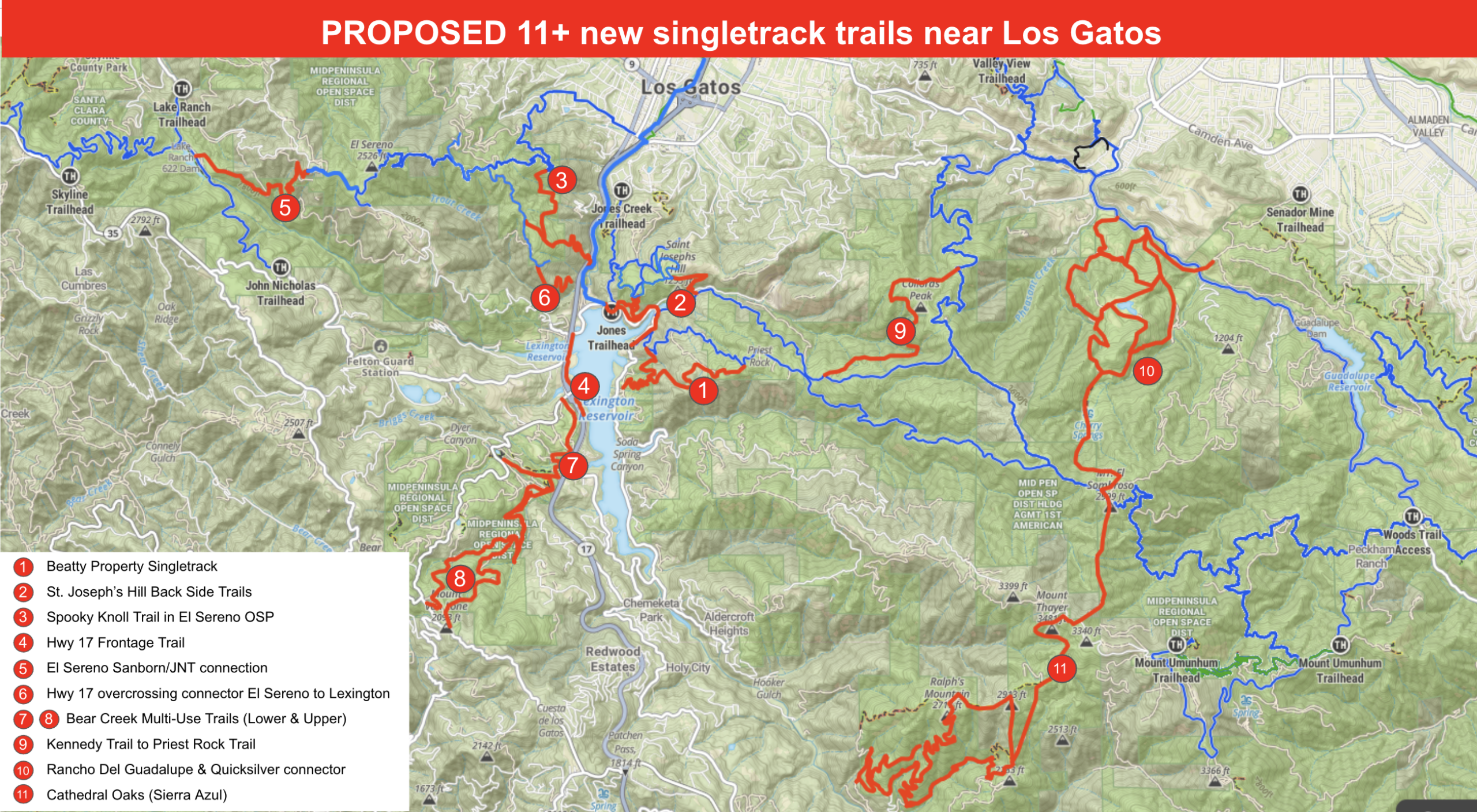
Los Gatos Area Advocacy Priorities
Help us bring more bike-friendly trails to the South Bay! We’re focusing on key trail access and development opportunities in the Los Gatos area. These priorities reflect feedback from riders, local advocates, and trail history. Details and Maps Below!
▶
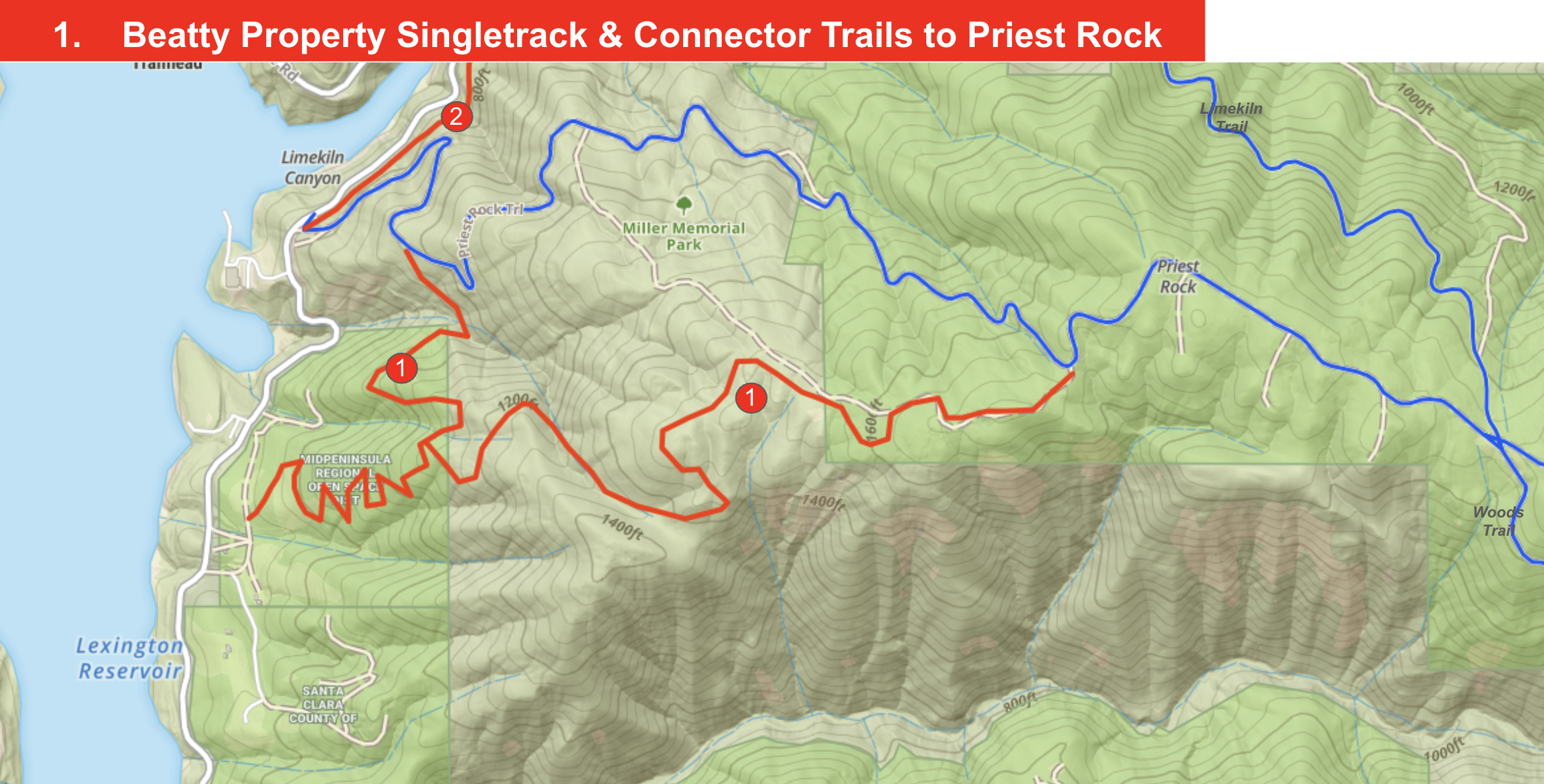
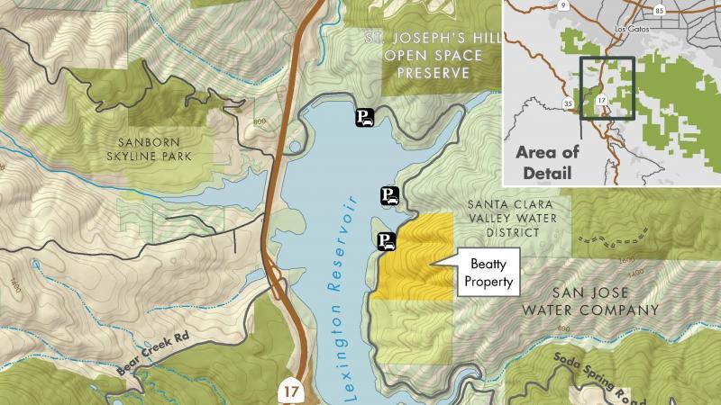
Beatty Property Single-track & Trails Near Priest Rock
What:
- Complete the Beatty Property Trail Connections Project.
- This project has been planned for many years and was delayed for an environmental study, now completed.
Why it matters:
- This trail enables a fun climbing single-track that avoids the steep climbs of Priest Rock trail and will connect to create multiple high-quality loops.
- This could reopen a rare single-track close to Los Gatos and connect to a high-quality loop.
- Ref: MROSD MAA – Portfolio 22
▶
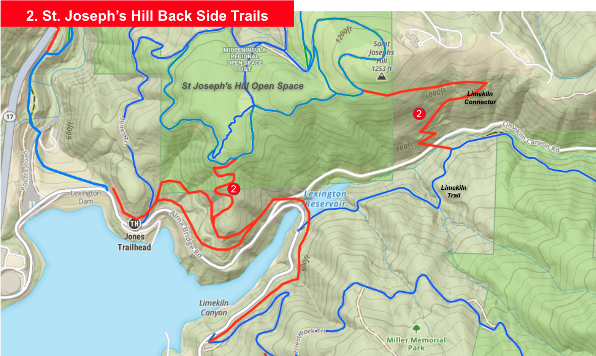
St. Joseph’s Hill Back Side Trails
What:
- Create a trail network on the southern side of St. Joseph’s Hill Open Space Preserve:
- Manzanita Trail to Limekiln Trail
- Jones Trail to Priest Rock
- Alma Bridge Rd to Manzanita Trail
- Los Gatos Creek to Jones Trail
Why it matters:
- St. Joe’s is overcrowded and lacks single-track.
- This trail network would reduce congestion, keep users off Alma Bridge Road and provide more bike-friendly routes.
- Enables several more trail only loops directly from downtown Los Gatos.
- Improve access, safety, and flow across one of the busiest trail systems in the South Bay.
- Ref: MROSD MAA – Portfolio 20
▶
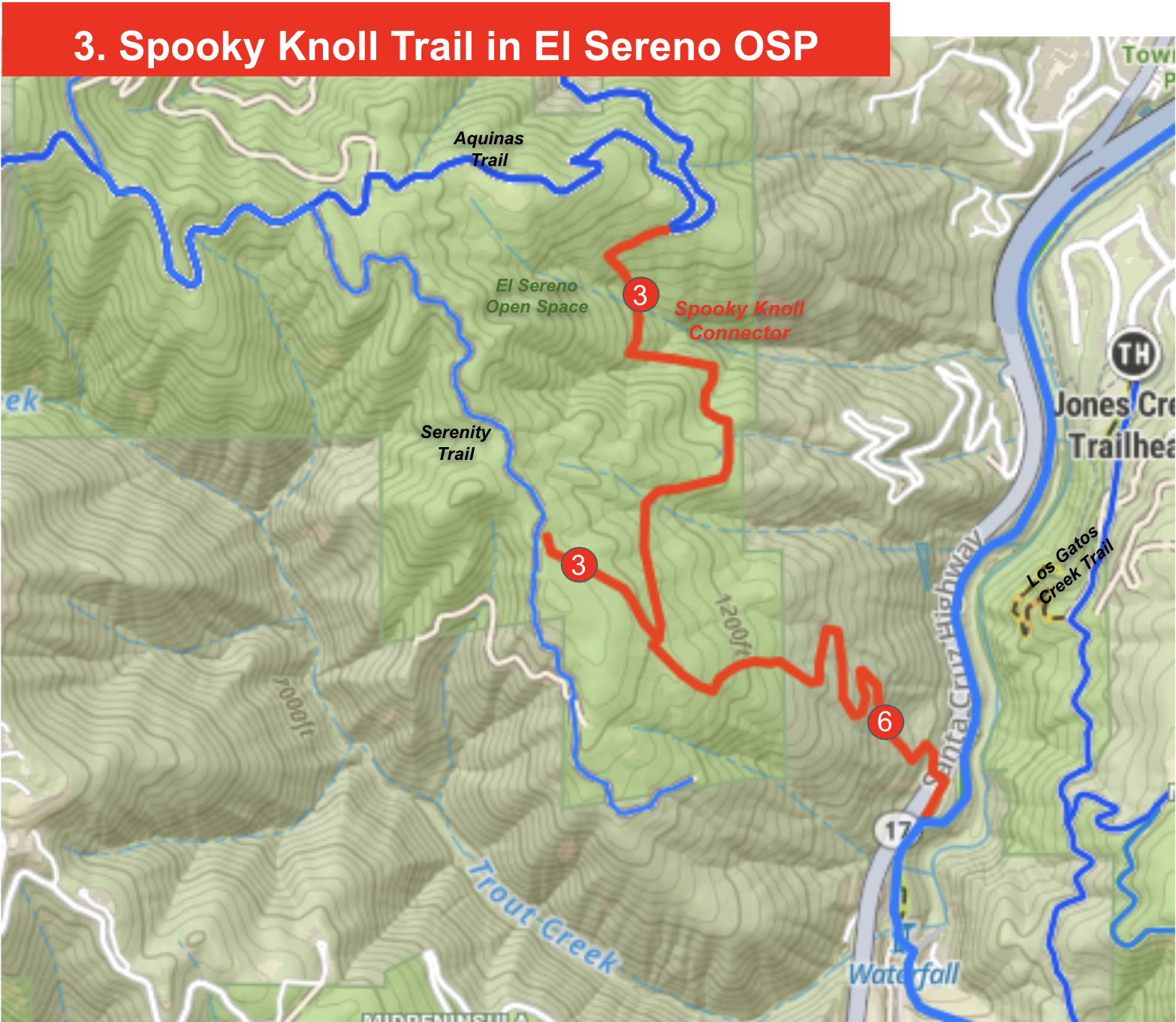
El Sereno Spooky Knoll Connector
What:
- Spooky Knoll Connector—construction has begun! This narrow trail (4’) connects the main Aquinas trail to Serenity trail and in the future to the Hwy 17 overcrossing trail that will descend towards Lexington Dam and other local trail networks.
- This trail will provide an interesting, narrow, multi-use trail through El Sereno OSP, different from the usual wide and steep fire roads.
Why it matters:
- El Sereno is close to town but mostly steep fire roads. The Connector follows an old wagon route ideal for bike-friendly features like berms and flow.
- It will serve walkers, runners, equestrians, and riders alike, filling a need for fun loops near Los Gatos.
- Links: Spooky Knoll and Highway 17
- Ref: MROSD MAA – Portfolio 20
▶
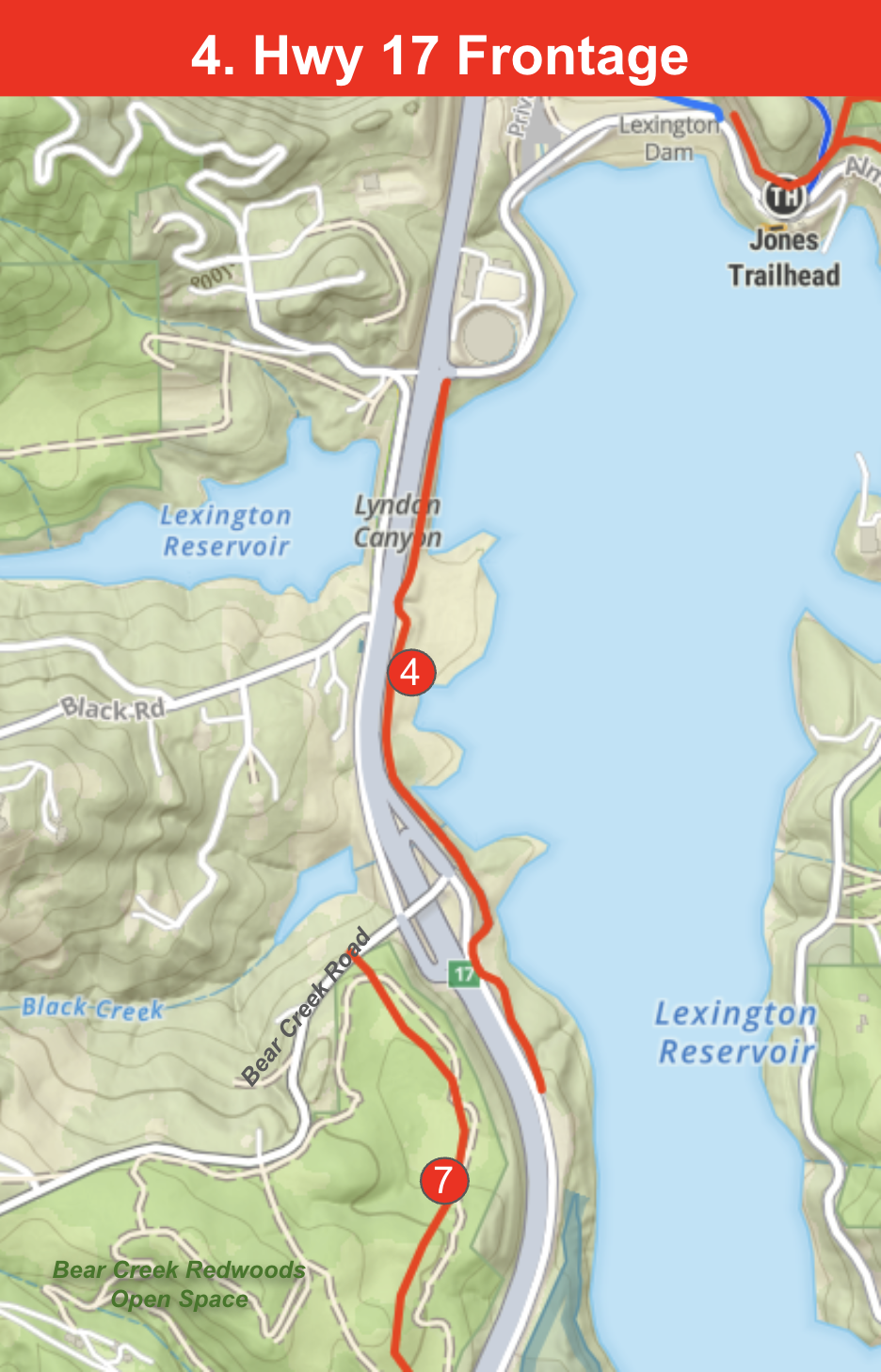
Highway 17 Frontage Trail – Los Gatos Creek to Bear Creek Overpass
What:
- This heavily used lake front trail connects the Los Gatos Creek Trail and Alma Bridge Road to the Bear Creek Overpass and the future Bear Creek Redwoods multi use trail.
- This trail provides a continuous off-highway corridor for riders, runners and hikers between key Los Gatos trail systems.
- This trail is used year-round AND needs major maintenance work to address drainage to make it a sustainable all-season trail. Please watch for upcoming volunteer trail days @ SVMTB.org
Why it matters:
- Keeps riders safely off Highway 17 while offering the most direct route between Montevina Road, Black Road, and Bear Creek Road connections to the Los Gatos Creek Trail and Midpen trail network.
- Improves regional connectivity for road, mountain, and gravel riders while also serving students commuting to Los Gatos High School.
- Creates a safer, multi-use alternative for both recreation and local transportation.
- Ref: Potential addition to the Santa Clara County Active Transportation Plan.
▶
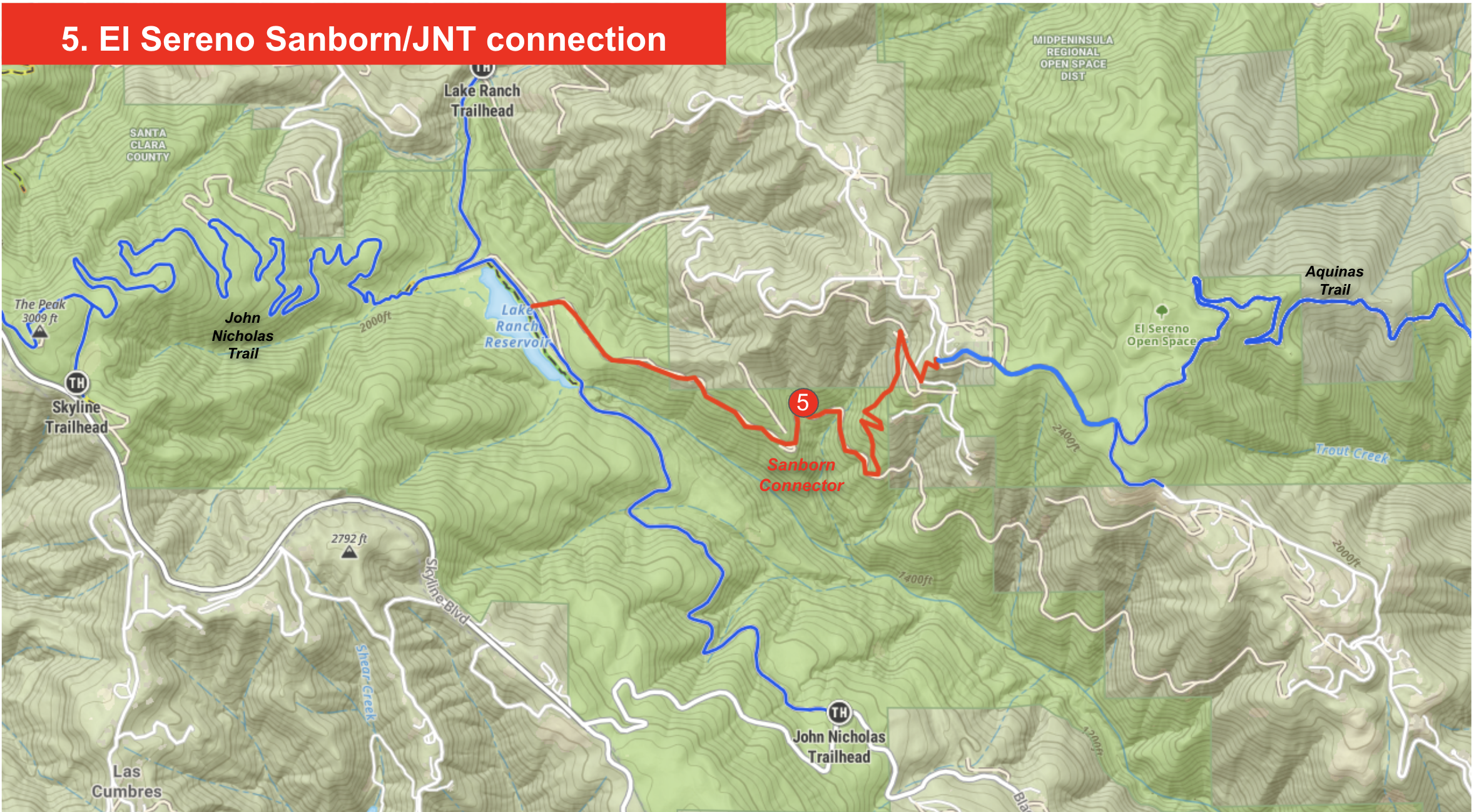
El Sereno to Sanborn/JNT connector
What:
- Create a trail connector between El Sereno and Sanborn Park. This segment is part of the Bay Area Ridge Trail
- Utilize existing PG&E road to build a ridge-to-ridge dirt connection.
Why it matters:
- Getting from Los Gatos to Sanborn (and the very popular John Nicolas Trail) means a drive or a long ride via narrow asphalt roads (e.g., up Black Rd).
- This connector will enable riders from downtown Los Gatos to ride to Skyline and onwards to Castle Rock all on trail.
- This connector would serve hikers, bikers, and equestrians, while reducing Bear Creek Rd parking issues.
- Ref: MROSD MAA – Portfolio 19
▶
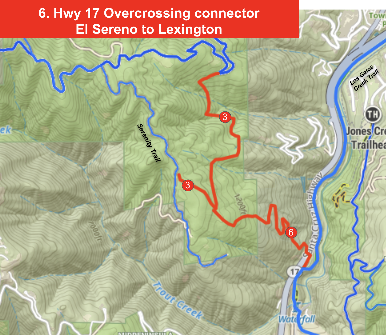
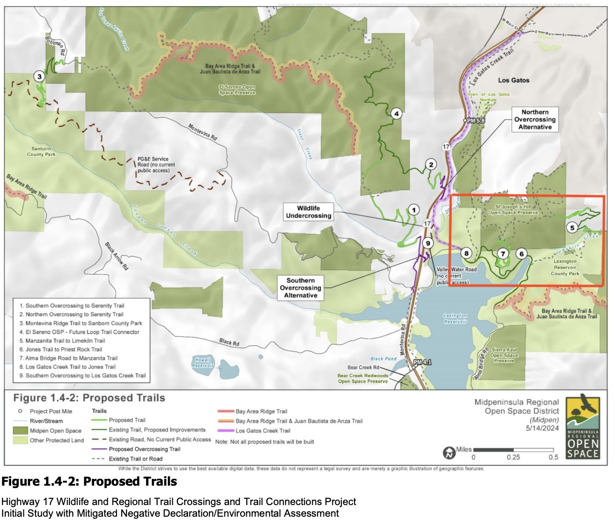
Highway 17 Overcrossing Connector – El Sereno to Lexington
What:
- Support completion of the Highway 17 Wildlife and Trail Crossings Projectconnecting El Sereno Open Space Preserve to Lexington Reservoir County Park.
- Ensure these alignments are fully multi-use and integrated into the Bay Area Ridge Trail network.
Why it matters:
- This connection is the missing link between El Sereno, Lexington Reservoir, and the Los Gatos Creek Trail.
- Provides a safe and scenic route over Highway 17 for hikers, equestrians, and cyclists—eliminating the current divide between two major regional trail systems.
- Critical for completing the Bay Area Ridge Trail through the Santa Cruz Mountains and connecting to the Midpen and County trail networks.
- Strong public support and funding partnerships are already in place via Midpen’s official project.
- Ref: MROSD Highway 17 Wildlife & Trail Crossings Project, Caltrans, and Santa Clara County Parks coordination.
▶
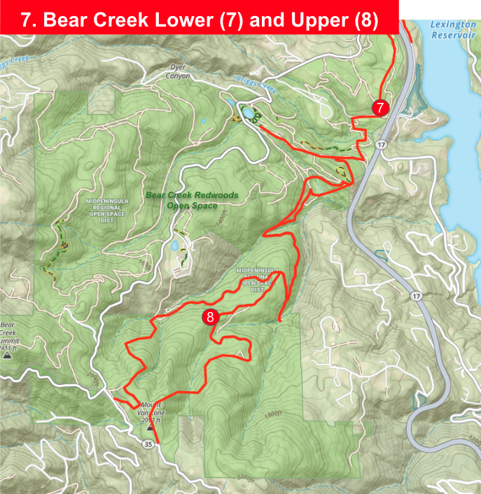
Bear Creek Redwoods Multi-Use Trail
What:
- Advocate for a new multi-use bike legal trail through Bear Creek Redwoods Open Space.
- Lower trail head at the Bear Creek Road overpass and upper trail head on Summit Road.
Why it matters:
- Bear Creek Redwoods Open Space is currently closed to bikes.
- This would provide legal, purpose-built trails for hikers and bikers.
- Relieve pressure from other preserves and provide sustainable flow options.
- Ref: MROSD MAA – Portfolio 21
▶
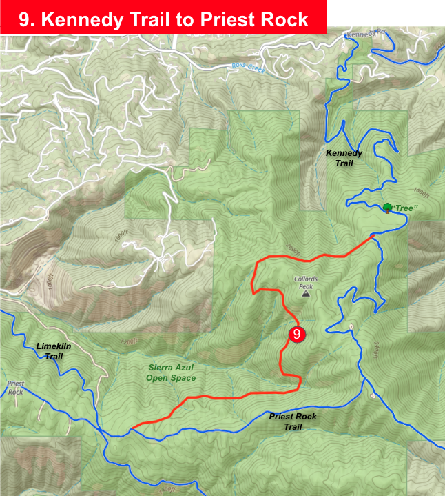
Kennedy Trail to Priest Rock Trail – Singletrack Bypass
What:
- Construct a new singletrack trail connecting Kennedy Trail directly to Priest Rock Trail, bypassing the steep and eroded fire road section.
- Trail would follow a sustainable contour alignment—approximately 4 feet wide—to maintain multi-use access while providing a more enjoyable grade for riders and hikers.
- This segment would replace the notoriously steep “Billy and Bob” (or “Three Witches”) section with a safer, shaded route more in character with modern trail standards.
Why it matters:
- The current Kennedy fire road is excessively steep and prone to erosion, discouraging many users and requiring ongoing maintenance.
- A new singletrack bypass would create a smoother, more sustainable link between two of the most popular climbing routes in the Lexington area.
- Improves access for mountain bikers, hikers, and runners while reducing long-term environmental impact from storm runoff and rutting.
- Also creates an interesting loop opportunity for those who still want to climb to the top via the existing steep route and descend the new singletrack.
- Ref: Potential Midpen or County Parks collaboration for sustainable trail reroute design.
▶
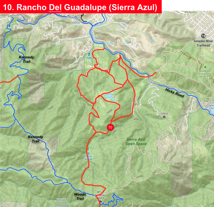
Sierra Azul – Rancho de Guadalupe / Kennedy to Hicks
What:
- Explore long-term trail connections between Kennedy Ridge and Rancho de Guadalupe.
- Use existing 4WD/wagon routes to create loop options with big elevation and views.
Why it matters:
- This area is in Midpen’s Vision Plan but still closed. It offers incredible potential if designed right.
- Ready the case for future trails using topo maps, old roadbeds, and boots-on-ground knowledge.
- Ref: MROSD MAA – Portfolio 24
▶
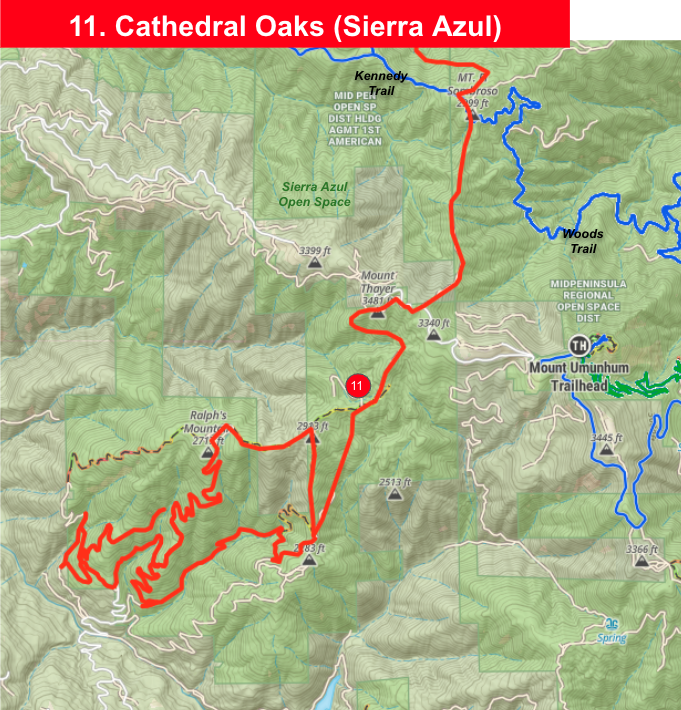
El Sombroso Trail Connection – Cathedral Oaks Area (Sierra Azul)
What:
- New trail from the Cathedral Oaks Area to Mt. Thayer and El Sombroso in the Sierra Azul region.
- This connection would extend south from the Kennedy Ridge area, linking to existing service roads and future loop trail alignments near Mt. Thayer.
- Complements proposed loop trails that would connect existing roads and singletrack corridors to form a complete, rideable circuit.
Why it matters:
- Provides a critical link to Mt. Thayer and El Sombroso—currently isolated by steep fire roads and limited trail access.
- Would establish a continuous dirt connection from the Cathedral Oaks area through to upper Sierra Azul and Midpen’s high-elevation trail system.
- Offers new opportunities for loop rides and long-distance trail continuity across multiple preserves.
- Listed as project (60) in Midpen’s Vision Plan and referenced with complementary “Loop Trails” project (59) for regional connectivity.
- Ref: Midpen Vision Plan – El Sombroso Trail Connection & Loop Trails (Projects 59 & 60)
Tell Us What You Think
Got a favorite trail idea? Share your thoughts to help us prioritize: